Main article: Geography of Brazil

Topographic map of Brazil.
Brazil is the fifth largest country in the world, and third largest in the Americas, with a total area of 8,515,767.049 km2 (3,287,956 sq mi),[143] including 55,455 km2 (21,411 sq mi) of water.[15] It spans four time zones; from UTC−5 comprising the state of Acre and the westernmost portion of Amazonas, to UTC−4 in the western states, to UTC−3 in the eastern states (the national time) and UTC−2 in the Atlantic islands.[144]
Brazil is the only country in the world that has the equator and the Tropic of Capricorn running through it. It is also the only country to have contiguous territory both inside and outside the tropics. Brazilian topography is also diverse and includes hills, mountains, plains, highlands, and scrublands. Much of the terrain lies between 200 metres (660 ft) and 800 metres (2,600 ft) in elevation.[145] The main upland area occupies most of the southern half of the country.[145] The northwestern parts of the plateau consist of broad, rolling terrain broken by low, rounded hills.[145]
The southeastern section is more rugged, with a complex mass of ridges and mountain ranges reaching elevations of up to 1,200 metres (3,900 ft).[145] These ranges include the Mantiqueira and Espinhaço mountains and the Serra do Mar.[145] In the north, the Guiana Highlands form a major drainage divide, separating rivers that flow south into the Amazon Basin from rivers that empty into the Orinoco River system, in Venezuela, to the north. The highest point in Brazil is the Pico da Neblina at 2,994 metres (9,823 ft), and the lowest is the Atlantic Ocean.[15]
Brazil has a dense and complex system of rivers, one of the world's most extensive, with eight major drainage basins, all of which drain into the Atlantic.[146] Major rivers include the Amazon (the world's second-longest river and the largest in terms of volume of water), the Paraná and its major tributary the Iguaçu (which includes the Iguazu Falls), the Negro, São Francisco, Xingu, Madeira and Tapajós rivers.[146]
- Geography of Brazil
-

-

-


Climate
Main article: Climate of Brazil

Brazil map of Köppen climate classification.
An equatorial climate characterizes much of northern Brazil. There is no real dry season, but there are some variations in the period of the year when most rain falls.[147] Temperatures average 25 °C (77 °F),[149] with more significant temperature variation between night and day than between seasons.[148]
Over central Brazil rainfall is more seasonal, characteristic of a savanna climate.[148] This region is as extensive as the Amazon basin but has a very different climate as it lies farther south at a higher altitude.[147] In the interior northeast, seasonal rainfall is even more extreme. The semiarid climatic region generally receives less than 800 millimetres (31.5 in) of rain,[150] most of which generally falls in a period of three to five months of the year[151] and occasionally less than this, creating long periods of drought.[148] Brazil's 1877–78 Grande Seca (Great Drought), the worst in Brazil's history,[152] caused approximately half a million deaths.[153] A similarly devastating drought occurred in 1915.[154]
South of Bahia, near the coasts, and more southerly most of the state of São Paulo, the distribution of rainfall changes, with rain falling throughout the year.[147] The south enjoys subtropical conditions, with cool winters and average annual temperatures not exceeding 18 °C (64.4 °F);[149] winter frosts and snowfall are not rare in the highest areas.[147][148]
- Climate of Brazil
-


Biodiversity and environment
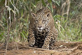
Brazil's large territory comprises different ecosystems, such as the Amazon rainforest, recognized as having the greatest biological diversity in the world,[155] with the Atlantic Forest and the Cerrado, sustaining the greatest biodiversity.[156] In the south, the Araucaria pine forest grows under temperate conditions.[156] The rich wildlife of Brazil reflects the variety of natural habitats. Scientists estimate that the total number of plant and animal species in Brazil could approach four million, mostly invertebrates.[156]
The Amazon rainforest, the richest and most biodiverse rainforest in the world.
The natural heritage of Brazil is severely threatened by cattle ranching and agriculture, logging, mining, resettlement, oil and gas extraction, over-fishing, wildlife trade, dams and infrastructure, water pollution, climate change, fire, and invasive species.[155] In many areas of the country, the natural environment is threatened by development.[159] Construction of highways has opened up previously remote areas for agriculture and settlement; dams have flooded valleys and inundated wildlife habitats; and mines have scarred and polluted the landscape.[158][160] At least 70 dams are said to be planned for the Amazon region, including the controversial Belo Monte hydroelectric dam.[161]
- Biodiversity of Brazil
-

-
-


No comments:
Post a Comment